Los Angeles Fire Dept. and UC San Diego WIFIRE Team Join Forces to Fight Wildfires

The Los Angeles Fire Department, recently challenged by yet another series of late summer wildfires, has successfully tested a new web-based tool developed by University of California San Diego researchers to perform data-driven predictive modeling and analysis of fires that have a high potential for rapid spread.
Called Firemap, and developed by the University’s ‘WIFIRE’ collaboration, the new tool enables a ‘what-if’ analysis of fire scenarios ahead of the time as well as real-time fire forecasting. The overall goal of WIFIRE, the result of a multi-year National Science Foundation (NSF) grant, is to make data and predictive models readily available so that the direction and rate of fire spread can be known as early as possible to assist in rescue and containment efforts.
WIFIRE’s Firemap data resource also provides easy access to information on past fires, past and current weather conditions as well as weather forecasts, satellite detections as fast as they are received, HPWREN camera images, and information on vegetation and landscapes from a variety of sources. These are all datasets available on different websites that viewers can now see in one place, achieve programmatic access via web services, and be used for planning fire response and management of natural resources well ahead of time.Firemap has already attracted some interest of a number of fire departments and was recently presented at the 20th Anniversary of the Annual Lake Tahoe Summit, where President Obama gave a keynote address on the importance of partnerships and innovation in tackling our shared climate and conservation challenges.
“WIFIRE is a great example of how distributed data sets can be used within an integrated system to transform that information to action in real-time for an effective decision support and response,” said Ilkay Altintas, chief data science officer at the San Diego Supercomputer Center (SDSC) at UC San Diego, a principal investigator for WIFIRE and an affiliate of the Qualcomm Institute. “While all the information we use in WIFIRE existed previously, it wasn’t yet integrated to real-time predictive analyses and modeling in a way the fire community can take advantage of it instantly.”
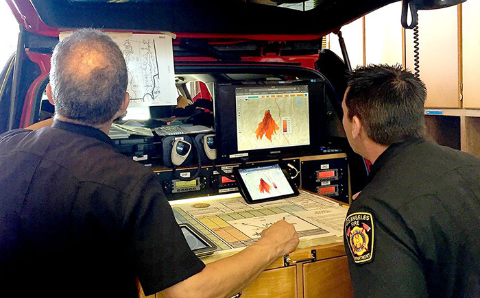
Since the fall of 2015, the WIFIRE team has had a partnership with the Los Angeles Fire Department (LAFD) focused on a pilot study to use WIFIRE’s new Firemap tool in real-time fire situations. The WIFIRE team and LAFD tested the operational aspects of the developed technology on a drill in July 2016. In addition, in the Sand, Blue Cut, and Soberanes fires, which burned more than 200,000 acres combined in California earlier this summer, the WIFIRE team shadowed the actual fire progression with Firemap. The comparison between the fires’ actual daily progression and WIFIRE’s real-time prediction model were extremely close.
| Bits for Fire: New Server Provides Real-Time Weather Data to Fire Modeling ToolsResearchers at the University of California San Diego’s Qualcomm Institute (QI) have completed work on a new data exchange server that will provide the most recent weather data to anyone, including fire crews, to enable more accurate simulations and potentially save property and lives.The Environmental Data Exchange (EDEX) server was created by QI Senior Development Engineer John Graham and QI Director of Visualization Tom DeFanti with a $20,000 grant from the National Science Foundation’s Unidata Equipment Award Program.The server makes the data available on the 40 Gb/s ‘Prism’ network based at UC San Diego. It makes high-resolution weather data available to researchers worldwide and enables visualization of weather systems and events lasting months or even years. Predictive fire models and the fire response community will be making use of the EDEX via the WIFIRE Firemap tool.“Before EDEX, the information available to Firemap’s fire models were limited in terms of temporal resolution,” said Graham. “We’ve integrated the EDEX data into Firemap so the tool can ingest data on larger distances over greater timespans. Researchers or first responders can, with one button, request current forecast model data as well as data from the nearest weather station through the Firemap web interface. Instead of once per hour, they receive a forecast animation every 15 minutes.” |
|---|
To be truly vetted and operationally functional, WIFIRE needed a fire department to partner with. Recognizing the opportunity to leverage technology for his commanders making life and death decisions, LAFD Fire Chief Ralph Terrazas contacted Altintas to assist with the program development.
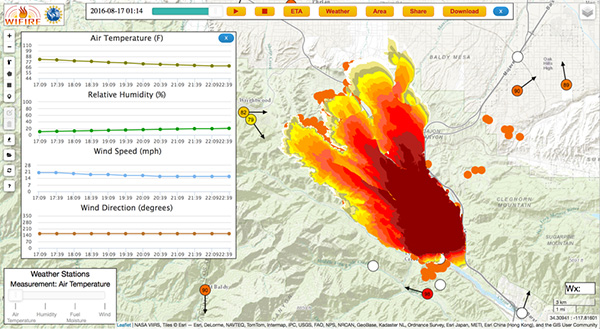
A screenshot of WIFIRE’s Firemap resource tracking the Blue Cut Fire on August 17, 2016. Ilkay Altintas/SDSC
“For Incident Commanders (IC), the WIFIRE Firemap is one of the most progressive decision making tools developed in the last decade,” said Terrazas. “Firemap gives the IC accurate and real time data to help make command decisions when prioritizing resource allocation or which communities to evacuate. This has never been available during the initial action phase of brush firefighting, and it has been an honor to work with the WIFIRE team and see their dedication to public safety.”
UC San Diego was awarded the NSF grant in late 2013 to build an end-to-end cyberinfrastructure to monitor and manage real-time and data-driven simulation, prediction, and visualization of wildfire behavior. The WIFIRE project includes researchers from SDSC, as well as the university’s California Institute for Telecommunications and Information Technology’s (Calit2) Qualcomm Institute, and the Mechanical and Aerospace Engineering (MAE) department at the Jacobs School of Engineering. The University of Maryland’s Department of Fire Protection Engineering is also a project participant.
“We are very excited about our partnership with the LAFD, which enabled our team to work closely with firefighters to test the usefulness of our tools in real-time, and helped the WIFIRE team to more effectively calibrate our research protocol in terms of actual operational aspects,” said Altintas. “Based on this collaboration, we look forward to making our modeling tools and data services available to other fire research, response, and emergency management teams throughout other regions where wildfires pose a significant threat to communities.”